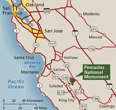
Jeff always has Mondays off (his ONLY day off, in fact) and the kids and I were both off as well in honor of Veteran's Day. We took off to Pinnacles National Monument for a terrific fall day of hiking and rock scrambling. The hike we did was a loop that included cave exploration, a small water reservoir, over 1400 feet of elevation gain, hiking up some steep, narrow rocky volcanic areas, and even a sighting of a California Condor. I plan to bring our Jaunt Adventure Group here in a couple of weeks, so here's a trip report for those wishing to come along.
We left Modesto about 9 am and were on the trail by 11:30. We probably spent a half hour at the visitor's center and restrooms, so it's about a 2 hour drive. Because it was Veteran's Day, entrance to the park was free, but usually it is $5 per vehicle. There was plenty of parking at the trailhead, in the Bear Gulch Day Use Area.
This unique wilderness area is volcanic, remnants of a volcano that was actually located almost 200 miles away, near Los Angeles! It is here, now, because of moving plates and fault lines (the visitor's center has a nice display that teaches about the geology and history of this area). It is hot and dry here in the summer, and cool in the winter, with moderate rainfall. The fire danger right now is HIGH, as it is super dry. There are no campfires allowed, and smoking on the trail is prohibited.
 |
| Bear Gulch Caves area |
 |
| The kids attack the beginning of the uphill along the High Peaks Trail |
After coming out of the cave area, you find the Bear Gulch Reservoir. The endangered California Red Legged frog is endangered but making a comeback, and can be seen at the reservoir, but we didn't get lucky enough to spot one. From the reservoir you catch the Rim Trail, and it goes mostly uphill. Eventually you meet up with the High Peaks Trail, still heading up. Up at Scout Peak there is an outhouse toilet and a bench on which to take in the view. You can see a parking lot, but it isn't the one we started at. It was 2 miles from the caves to Scouts Peak.
 |
| Parts of the High Peaks Trail are steep and narrow |
From Scouts Peak you get into the really fun part of the High Peaks trail - you are walking up steep rock, with the aid of handrails. It is from up here where we saw the beautiful California Condor flying. We also ran into a ranger who was using a radio antenna to pick up the signals of the condors, which are all radio collared. This .7 mile stretch of the trail is incredibly beautiful with so many rocky spires and different views out to different directions.
 |
| Park staff monitoring the radio signals of the condors, all of which are tagged |
Join us November 23, Jaunt Adventure Group hike information:
To attend the hike: please send an email to jauntwithus@gmail.com
Meet-up Place: Jaunt Adventure Gear, 1508 10th Street, Modesto
Time: 8:00 (departure by around 8:15)
The hike options:
- short option, see the caves twice - hike to explore Bear Gulch caves and picnic at the reservoir, 1.7 miles one way. Return via the same route, 3.4 miles total
- another short option - hike to explore Bear Gulch caves and continue past the reservoir onto the Rim Trail for viewing some rocky features and return to parking area, a 3 mile loop trip
- longest option - hike to explore Bear Gulch caves, see the reservoir, continue on into the High Peaks area (this is the route Blogged about above). About a 6 1/2 mile loop, with over 1400 feet in elevation gain. This option is more strenuous, and may not be suitable for those people afraid of steep, narrow heights/cliffs.
What to bring:
- water, 2-3 liters per person. There is NO water anywhere on the trail. Carry 3 if you plan to do the longest option
- flashlight or headlamp for exploring the caves
- comfortable shoes, moisture-wicking socks, layers of clothing. The cave section is very cool, while the exposed section between the Rim Trail and Scouts Peak is very hot.
- sun hat, sun screen, sunglasses
- toilet paper, wipes, ziplock baggies
- knife, first aid kit
- food - enough calories to fuel your hiking for the day (you might try bagels and peanut butter, cheese and crackers, fresh cut-up fruit or dried fruit, nutty trail mixes, Pay Day/Snickers, cut-up carrots/sweet peppers/celery, jerky)
- optional but worth the weight - camera, binoculars, trekking poles
I am looking forward to hiking this with you - it is such an incredible place to visit. Make sure to sign-up using the email address above, as I will send out the final meet-up details a few days before. Anyone is welcome, bring your family and friends - just let me know that in the email. Thanks!
copyright Nicole Cipriano. All rights reserved.
Please do not copy or repost any content or photos.
Instead, please post the link to the Blog.
Instead, please post the link to the Blog.


