Thursday, April 25, 2013

Tuolumne Meadows Tentative Opening

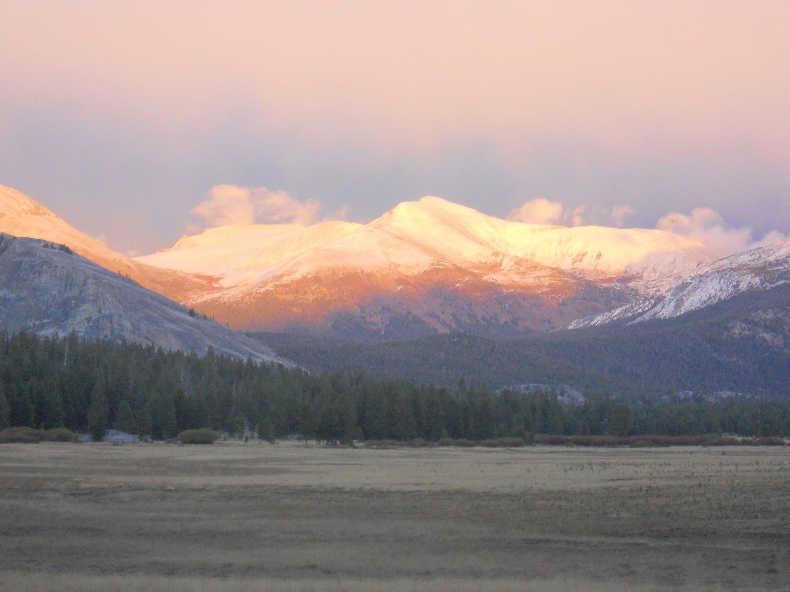
Tuolumne Meadows, Oct. 2012
taken pre-storm (we had to go to lower elevation to camp!)

I am torn between being excited that on May 11 Tioga Pass Road may open, or sad that it means we have very little snow pack.  I guess at this point I'll choose excited - time to plan the next Jaunt Adventure Group hike!

Playing on an iced over puddle near Olmstead Point

There are so many hikes that take off from Tioga Pass, and a few can be done early season, but there will be parts of the trails that are snow covered or muddy.  I'll get to planning in the next week, and have a back-up plan in case we get some weather and the road doesn't open.  Back-up plan will probably be Henry Cowell Redwoods or Big Basin, both coastal redwoods areas.

4 years ago; the meadow greens up nicely in spring & summer

So stay tuned in the next week as I research which hike we can do early spring.  For this one I may get us going further, and with the high elevation of this area, it may not be as kid friendly to take a trail, but kids love just walking along the river and playing in the meadow itself.  So as always, all will be welcome and there will be options.  


Thursday, April 4, 2013

Living Rancho History & Coastal Hiking


One of the many beaches along the Ohlone Bluff trail at Wilder Ranch State Park

On Sunday, April 14, we have the opportunity to hike along the bluffs of the Pacific Ocean, explore its many beaches, AND participate in a day of early California ranching history. Between 11:00 & 3:00 there will be many hands-on activities like butter churning, roping skills, wagon rides, and games like tug o' war and hoops. The kids will love this day at Wilder Ranch State Park! 

It's about a 2 hour drive and costs $10 cash to enter the State Park.  We'll first check out the ranching activities, then hike the flat trail along the bluffs which afford us spectacular views of the water, cliffs, and farm fields.  Along the trail we'll find a beach on which to picnic, allowing the kids to find the caves, and meander in some waves and get full of sand.  If you are along without kids and up for more of a workout, the trail CAN lead you on for 6 to 10 mile loop, but our kid group will go out and back for just a couple miles or so. Or if you're a runner, bring along those running shoes and get your run on, we can meet up later at a sandy cove. 


Quick History Lesson:
In 1791 this land became Rancho Matadero, started by the Santa Cruz Mission, and its purpose was to supply the mission with food.  The Wilder family operated it as a successful dairy for nearly 100 years, and in 1974 the California Department of Parks and Recreation took over.  The ranch's buildings, barn, gardens, and Victorian house still stand, and are open to the public. 


Sea Lions hang out and play and can be seen from a "secret" beach.

The park spreads along the east and west sides of Highway 1 and has more than 30 miles of hiking, biking, and horse trails.  We will hike the Ohlone Bluff Trail, which is flat and looks out to the ocean the whole time.  There are many spur trails going down to beaches that are perfect for exploring and having a picnic. 


 If you are interested in coming along, 
please send an email to Nicole at jauntwithus@gmail.com.

If you are already on the group email, you're in the know already, and I will send out the group email with meet-up details a week or so before.

(I never post the meet-up details on this public site - who knows what "strangers" could stumble upon it, so I do all that info. via email for safety.)


Monday, March 11, 2013

Mark Your Calendar: March 30


Time for the Next Hike!
Saturday March 30, 2013 (Easter weekend)
Red Hills, Chinese Camp (south of Jamestown)

Send an email to Nicole at 
jauntwithus@gmail.com 
to sign up.  
I'll add you to the group email list 
and email you the trip details the week before the Jaunt.
For this hike we will meet-up around 9:00 - a later start for those of you who couldn't make it so early for the February hike!  


Red Hills
My daughter, when she was 5, & her friend, when he was 3
Start 'em young!

This route at Red Hills is kid friendly because it isn't really long, about 3 miles, (more distance can easily be added for those who want it) and it is mostly flat.  Well, there is one steep hill at the beginning, but it is short.  From the top of it you have a nice view into the mountains.  The rest of the way is peppered with short rolling ups and downs, and lots of flats.  The trail is shared with horses and mountain bikers, and dogs are allowed. (Dogs should have rattlesnake vaccination to hike here.)


 If we get lucky and get some rainfall before the 30th, the creeks will be nice.  I've been there when they are completely dry.  Nothing feeds them except rainfall running off the  hills.  March and April are the best times to visit to see wildflowers, as later in the summer it gets HOT and DRY.  There are usually quail, chickadees, and other birds to see.  


As usual, bring the following in a day pack:  at least 1 liter (32oz) of water, snacks, sunscreen, hat with brim, layered clothing, comfortable shoes, and your camera.  Let's get out there and enjoy spring in the hills!  

Tuesday, February 12, 2013

Let's Go to Mt. Diablo!

Our family had a great time camping at Mt. Diablo State Park this weekend, and we are  geared to get you out hiking on February 23rd!

A huge Live Oak in Juniper Campground

To sign up to jaunt with us at Mt. Diablo on Feb. 23, send an email to Nicole at 
jauntwithus@gmail.com.
Then you'll get an email back with trip details, like the meeting place and time, and what to bring. 

The drive is less than 2 hours, and goes up the 680 freeway into Danville.  

A view from the summit (hiking along the Mary Bowerman Trail)

The view we had at night of the Bay Area city lights from our tent site was incredible,  but what we saw during the day from the summit was even better!  (This state park closes at sunset, so if you ever want to see the night view, you will have to camp.)

The wind had come up during the night, and continued as we explored the trails and summit the next day.  Our tents and down bags kept us and the kids plenty warm, but getting up for the day was another thing.  It was a cold morning!  It is common that down in the valley it is warmer and not windy, while up on the mountain it is colder and quite windy.  So if you jaunt with us here, wear layers and maybe gloves and a knit hat.

Vegetation around the mountain varies.
Here there are wild oats in the grasslands.

We explored 1 mile of the 2 mile trail that leaves Juniper Campground and goes all the way to the summit of Mt. Diablo.  It is all up hill, but never very steep.  Many spots along the way begin to offer peeks of what will be a panoramic on the summit.  The trail offers nice rest spots for snacks and photos.  


Summit Visitor's Center, built in 1939

People can hike to the summit, or drive there, and many ride their bikes up, too.  (The Amgen bicycle race will happen in Mt. Diablo in May again this year.)   You can park right by the Visitor's center.  We hung out inside for quite awhile since it was so warm and toasty in there!  It has a small shop, and the upstairs has a great place to learn about the geology, natural environment, and history of this unique place.  There's even a seating area with books to read, complete with an electric fireplace.  The observation deck is closed until later in the spring, but great views are available right in the parking lot.  

Another spectacular view from the 3,849 foot summit

We found stunning views on the Mary Bowerman Trail.  It starts in a lower parking lot, and has a trail guide with numbered markers that tell about what you see along the hike.  On this trail you literally walk around the summit, so by the time you are done you've seen a 360 degree view of the area.  It was a really clear day; we saw the Golden Gate and beyond, and even sighted Mt. Lassen way up north.   What's interesting is how the vegetation is different depending on what side of the mountain you're on.  When we got around 3/4 of the way it was so nice to soak up some sun and really warm up!  Where we had started the trail had ice on it!

After taking down camp, we headed back out to the South Gate, but made sure to stop at Rock City.  Rock City is amazing, but really disappointing because of all the damage people have done over the years.  Here are large sandstone rock formations that have been here for 50 million years, and there is a ton of permanent damage from people carving and even painting on them. So sad!  But the kids had fun climbing, finding "wind caves" to hide in, and just doing the exploring that kids like to do.  

One of many sandstone formations at Rock City

Options for Feb. 23 Jaunt:
1. Drive to the summit.  Explore the visitor's center.  Walk the Mary Bowerman Trail around the summit.  (Less than a mile walk, mostly flate.) 

2. Hike up 2 miles from Juniper Campground to the Summit.  Explore the visitor's center.  Possibly do the Mary Bowerman Trail around the summit (it is less than a mile).  Hike back down to Juniper, or drive down with someone in the group who chooses to drive to the top.  

3. Do option 1 or 2, then also hike over to North Peak, which would add just over another 2 miles to your day.  

There are many picnic spots tucked away
all through the park.  


Thursday, January 31, 2013

Time for a Late Winter Hike!

We've had such little snowfall this season that concerns are being raised about our water supply. In California water is absolutely vital for farming, and of course for cities as well. January is usually the wettest month of the year for us, and we hardly had any  precipitation this January. Our hiking group was planning to head to the Sierras to snowshoe, but there just wasn't enough recent snowfall to make it worth the jaunt.   

But, the foothills have greened up from the early season rainfall we did have, so it's time to get out and explore them!  We're headed to an ecological wonderland in the San Francisco Bay area - Mt. Diablo State Park.

3,849 ft. Mt. Diablo 


To Jaunt With Us on this late winter hike, send an email to 

jauntwithus@gmail.com

That way we can keep you posted on the details

February 23, 2013

We'll meet at Jaunt Adventure Gear 

1508 10th Street, Modesto

(the store will be open for retail sales in April!)


Sights to see along the trails in the park include its sandstone formations, rocky caves, and ancient fossils. Native flora consists of oak trees, grasses, and chaparral, as well as knobcone pine, Coulter pine, and digger pine.   Some trails allow for biking and horses, and there is a campground as well.  Dogs are not allowed on the trails.  The park can be accessed from the north, from Walnut Creek, or from the south, from Danville.


 Late winter is a great time to visit the park 
because summers are too hot and dry.

If the day is clear rather than hazy the views from the top of Mt. Diable are amazing: you have a panoramic view that includes the Golden Gate Bridge and the Farallon Islands, the James Lick Observatory, Mt. loma Prieta in the Santa Cruz mountains, Mt. Lassen up north, and the Sierra Nevadas to the east.   

A person can either hike to the top, OR drive right on up there.  Of course at Jaunt With Us we are geared to get you OUT OF YOUR CAR, so we will hike to the top!  There are a few ways to hike up there, some are longer than others.  We can choose a route that is shorter, such as the 2 mile round trip Juniper Trail, or we can try the 6 mile round trip up the summit trail.  Make sure you sign up soon via the email address above in order to receive trip details by February 16th.


Find our Jaunt Adventure Gear (our retail store)
on Facebook


"Like" us and you'll get store updates 


Saturday, November 17, 2012

Upcoming Hike Announcement

A ginko tree in our front yard 

Fall seems to take forever to arrive in the west, but it is finally here!  The trees are showing off their true colors, the air is cooler, and some rain has come.  Although it is beautiful, it can be more difficult to get up into the mountains when it has recently rained or snowed, and the mountain temperatures can be quite low, requiring the need for specialty clothing to be comfortable and safe while hiking, so for our next hike we will head to the coastal redwoods, where trails are easily accessible year-round.  

Jaunt With Us! 
Henry Cowell Redwoods State Park
December 8

The park is near Felton on Highway 9 in the Santa Cruz mountains.  

Some trees in the park are over 1,400 years old!

Banana slugs are commonly seen here

Temperatures this time of year are usually low 60's, but can change easily, so layered clothing is recommended for hiking here.

If you are interested in joining us on this jaunt, you need to sign up by sending an email to jauntwithus@gmail.com and that way we can send you the specific details a few days before.  


Sunday, October 14, 2012

Mono Pass Hike Preview

Read on to find out what to expect next week if you're coming along with Jaunt With Us! on our first group hike.  Also, check out the previous post for more details and how to sign up to do this jaunt with us: jauntwithus.blogspot.com/2012/10/welcome.html

A 3.7 mile hike to the Mono Pass sign
Our family was in need of a fall Jaunt, so we thought we'd go check out current conditions on the trail where we want to take you all next week.  Our original plan was to camp near the trail-head the night before, and then hike in the next morning with our gear to stay the night. Well, as we set up our tents at Aspen campground a few miles over Tioga Pass, the storm that was expected to come came in full force.  We had to readjust the backpacking plans since the storm was dumping snow up at the elevation of the hike - they even closed Tioga Pass road for the night and into the next morning.  Plan B, figured out while lying in the tent listening to the all-night long downpour, was to check out Bodie, the ghost town off 395, and let the kids explore Mono Lake.  The eastern side of the Sierras has so much to offer!  


Weather cleared as expected, so Saturday we hit the Mono Pass trail around 10:40 a.m.  The first part of the trail is in the 9000 feet elevation range, and trail conditions were dry, as seen in the photo below.

The first 2 miles of the trail has 2 short uphills, and there were some areas with snow on the trail, less than an inch, as we got higher or were in shady areas.


The last 1.7 miles leading to the Mono Pass marker sign has the longest uphill of the hike, but it isn't constant and has lots of rest spots (logs or rocks to sit on).  Once up at Mono Pass, the meadow areas had more than an inch of snow.


We knew we wanted to continue ten more minutes past the Mono Pass sign... 

so that we could get the vista of Mono Lake over 3000 feet below.  
Looking out to Mono Lake 

Hiking with a 6 year old meant frequent stops, so getting to this point took 3 hours.  Without her we could have made it in just over 2, I think, because our 9 year old keeps up a good pace.  After a warm lunch using our stove, and taking off our damp shoes and socks to let the feet dry a bit, we were ready to explore the mining cabins. (Jeff wore boots, and had perfectly dry feet, whereas the kids and I had shoes that let water in from the snow on the trail.  Wool socks are a life-saver because even when wet they still insulate, and no one's feet were cold until the end of the day.)

The day proved to be a gorgeous fall day, giving us the refreshment we sere seeking in the mountains.  We can't wait to share this spectacular piece of the Sierra Nevada with you next week on our first Jaunt With Us! hike.  

For more information on how to come along, see this post: jauntwithus.blogspot.com/2012/10/welcome.html