Monday, November 11, 2013

Pinnacles National Monument


Jeff always has Mondays off (his ONLY day off, in fact) and the kids and I were both off as well in honor of Veteran's Day.  We took off to Pinnacles National Monument for a terrific fall day of hiking and rock scrambling.  The hike we did was a loop that included cave exploration, a small water reservoir, over 1400 feet of elevation gain, hiking up some steep, narrow rocky volcanic areas, and even a sighting of a California Condor.  I plan to bring our Jaunt Adventure Group here in a couple of weeks, so here's a trip report for those wishing to come along.  


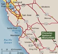
We left Modesto about 9 am and were on the trail by 11:30.  We probably spent a half hour at the visitor's center and restrooms, so it's about a 2 hour drive. Because it was Veteran's Day, entrance to the park was free, but usually it is $5 per vehicle. There was plenty of parking at the trailhead, in the Bear Gulch Day Use Area.  


This unique wilderness area is volcanic, remnants of a volcano that was actually located almost 200 miles away, near Los Angeles!  It is here, now, because of moving plates and fault lines (the visitor's center has a nice display that teaches about the geology and history of this area).  It is hot and dry here in the summer, and cool in the winter, with moderate rainfall.  The fire danger right now is HIGH, as it is super dry.  There are no campfires allowed, and smoking on the trail is prohibited.  

Bear Gulch Caves area
The caves in the Bear Gulch area are amazing!  They are talus caves created by huge boulders that formed a roof over a narrow canyon. Walking through the caves requires a flashlight, as some areas are completely dark.  The caves have some steep parts, and in some places there are stairs and handrails.  

The kids attack the beginning of the
uphill along the High Peaks Trail

After coming out of the cave area, you find the Bear Gulch Reservoir.  The endangered California Red Legged frog is endangered but making a comeback, and can be seen at the reservoir, but we didn't get lucky enough to spot one. From the reservoir you catch the Rim Trail, and it goes mostly uphill.  Eventually you meet up with the High Peaks Trail, still heading up.  Up at Scout Peak there is an outhouse toilet and a bench on which to take in the view.  You can see a parking lot, but it isn't the one we started at.  It was 2 miles from the caves to Scouts Peak.

Parts of the High Peaks Trail are steep and narrow

From Scouts Peak you get into the really fun part of the High Peaks trail - you are walking up steep rock, with the aid of handrails.  It is from up here where we saw the beautiful California Condor flying.  We also ran into a ranger who was using a radio antenna to pick up the signals of the condors, which are all radio collared. This .7 mile stretch of the trail is incredibly beautiful with so many rocky spires and different views out to different directions.  

Park staff monitoring the radio signals of
the condors, all of which are tagged
The last 1.7 miles of our loop went downhill along the Condor Gulch Trail and offered views of the high peaks which we had just explored. We hiked a total of about 6 1/2 miles and it took us just under 4 hours.  Today there was some cloud cover, which was nice.  The few times that the sun was full out, it was too warm; I can't imagine coming here except in fall, winter, & spring.  

Join us November 23, Jaunt Adventure Group hike information:

To attend the hike:  please send an email to jauntwithus@gmail.com

Meet-up Place:  Jaunt Adventure Gear, 1508 10th Street, Modesto

Time:  8:00 (departure by around 8:15)

The hike options:
  • short option, see the caves twice - hike to explore Bear Gulch caves and picnic at the reservoir, 1.7 miles one way. Return via the same route, 3.4 miles total
  • another short option - hike to explore Bear Gulch caves and continue past the reservoir onto the Rim Trail for viewing some rocky features and return to parking area, a 3 mile loop trip
  • longest option - hike to explore Bear Gulch caves, see the reservoir, continue on into the High Peaks area (this is the route Blogged about above).  About a 6 1/2 mile loop, with over 1400 feet in elevation gain. This option is more strenuous, and may not be suitable for those people afraid of steep, narrow heights/cliffs.
What to bring:
  • water, 2-3 liters per person.  There is NO water anywhere on the trail.  Carry 3 if you plan to do the longest option
  • flashlight or headlamp for exploring the caves
  • comfortable shoes, moisture-wicking socks, layers of clothing.  The cave section is very cool, while the exposed section between the Rim Trail and Scouts Peak is very hot.
  • sun hat, sun screen, sunglasses
  • toilet paper, wipes, ziplock baggies
  • knife, first aid kit
  • food - enough calories to fuel your hiking for the day (you might try bagels and peanut butter, cheese and crackers, fresh cut-up fruit or dried fruit, nutty trail mixes, Pay Day/Snickers, cut-up carrots/sweet peppers/celery, jerky)
  • optional but worth the weight - camera, binoculars, trekking poles
I am looking forward to hiking this with you - it is such an incredible place to visit.  Make sure to sign-up using the email address above, as I will send out the final meet-up details a few days before.  Anyone is welcome, bring your family and friends - just let me know that in the email.  Thanks!  


copyright Nicole Cipriano. All rights reserved.
Please do not copy or repost any content or photos.
Instead, please post the link to the Blog.


Wednesday, September 18, 2013

What to Bring on a Jaunt Adventure Group Hike

Jeff & son on Mt. Lassen 2012

I love how interest in our Jaunt Adventure Group is growing. It is my passion to get people out hiking, even if they've never hiked before.  The following things are what you should bring along with you in your backpack on day hikes with the Jaunt Adventure Group. 

1. Water Carry 2-3 Liters (8-12 cups) of water in your hydration bladder or lightweight bottles.  You should plan to drink 1-2 cups an hour to stay hydrated. 

LOVE Darn Tough socks, guaranteed for life, made in USA


2. Appropriate Shoes & Socks You don’t necessarily need special shoes, but a basic low-cut trail shoe will offer you traction.  As you grow into hiking, you may want a boot that offers support for going off trail more often and has waterproof qualities.  For our Jaunt hikes, make sure your shoes are comfortable and have been broken in.  Socks should be moisture wicking so your feet stay cool in summer and warm in winter.  They could be synthetic or my preference, wool.  Also, I suggest an extra pair of wicking socks so if your feet do get wet you can change.

3. Clothing Avoid cotton!  It gets wet from sweat, or if we have rain, and it will stay wet and heavy and you will lose precious body heat and feel cold.  Wear performance-type fabrics, like polyester, fleece, wool, even the older polypropylene because they will wick moisture away from your skin.  Wear layers to be prepared for weather changes.  You should have 3 top layers: a bottom layer, a mid layer like a fleece, and an outer layer jacket for wind or rain protection. Pants are usually better than shorts because you will have protection from sun, bugs, and scratches from trail brush.  Zip-off leg pants are ideal!

4. Headgear Think both sun protection and protection from cold – mountain conditions change frequently in a day.  You need a hat that has a brim, like a baseball cap or a brim all the way around.  But also bring a knit beanie for warmth. 

Jaunt's junior crew, Gaylor Lakes, Yosemite, June 2013


5.  Sunscreen & Sunglasses The sun can be more intense at higher elevations, so wear sunglasses and sunscreen, and bring a small tube of sunscreen along to reapply.

6.  Bug Repellant Don’t forget this, or it can be a miserable trip (not that I know this first-hand! Ha!)

7. Toilet Paper and Zip Lock Baggies While trailhead parking areas may have toilets, once we are on the hike it’s just trees and boulders.  Hiking areas require packing out your trash, so be prepared to put your wiping paper into a baggie in your pack to carry it out and throw it away in a garbage can.  That goes for all your candy and granola bar wrappers as well.  If you pack it in, then pack it out.  


Tuolumne Meadows, January 2012

8. Lunch A packable lunch should need no refrigeration for obvious reasons. (I don’t think you want to carry a cooler and heavy ice for miles.)  Here’s some ideas:  bagels (regular bread can get mushed in your pack), peanut butter, honey, fresh or dried fruit, trail nut mixes, beef jerky, salami sticks, cheese sticks (they don’t need the fridge), protein bars, or granola bars.  The web is full of homemade recipes for hiking foods such as wraps and energy balls.


9. Safety Essentials You may never use these, but if you ever need any of them at some point you will be glad you have them. 
 A knife or multi-tool.  I usually end up needing it once on every trip, if only for cutting my salami and cheese. 
 Light. A flashlight (with extra batteries) or headlamp is a must.  If you are ever out later than expected you don’t want to be in the dark without some light.
Matches/fire starter. I hesitate to include this after we just watched our precious Sierras burn up from an irresponsible hunter lighting a fire he was not supposed to light.  But a small, appropriately built fire can ward off hypothermia or be used as a signal fire for rescue.  A fire would only be lit in a true emergency, not just for ambience.   
First Aid Kit. Bandaids, wipes, gauze, butterflies, Advil/Tylenol, mole skin, etc. We sell these at Jaunt Adventure Gear.
Whistle. A whistle is much more effective than yelling in case you need to signal anyone of your presence. 


Afternoon thundershowers, summer, Yosemite

10. Optional Items 
  • Camera I bet you want photos of your adventure.
  • Trekking Poles Really nice to have along, as they help save your knees and provide balance
  • Binoculars Can be fun to use for wildlife viewing, scouting the lay of the land from a peak, etc.
  • Journal or sketchbook

Everyone is welcome to join a Jaunt hike, beginning hikers and advanced alike.  By being prepared with the items on the list, we can all help each other have a successful trip. 

And for all you experienced hikers, what's your take? Do you agree with my must-haves?  Did I leave anything out that you deem important?  I'd love for you to leave a comment.  


copyright Nicole Cipriano. All rights reserved.
Please do not copy or repost any content or photos.
Instead, please post the link to the Blog.


Friday, September 13, 2013

Why I Hike

Backpacking Santa Cruz mountains

As a typical busy American, working full time, and raising 2 school-age children, why is hiking my go-to activity whenever possible?  Because for me it counteracts the busyness. It provides me with an opportunity to get away from my never-ending to-do list. Hiking allows me to clear my head and to appreciate God’s amazing creation.  Plus, it counts as physical fitness, too!

Tetons, 2011

1.    Freedom:  I can pick the place and how I move in that place. Am I in the mood for bagging a peak, or meandering along a river?  Mountains or beach? (A perk of living here in the central valley of CA-I can pick either one!) a  National Park, or just forest land so I can bring the dog?  I can choose if I want to go slow or fast, stop and read or stretch or go faster and get a cardio workout, bring people or go alone… there is just freedom that feels nice compared to the usual routines of work, kids’ activities, etc.


Mt. Freel, Tahoe

2.    Creation:  I grew up on 6 acres of almonds and spent countless hours running around, climbing the trees, hanging out outside. My parents always took me on drives to Knights Ferry and to Pine Crest to walk and picnic.  I have always enjoyed being outside whenever possible.  Hiking allows me to feel appreciation for the Earth itself, the animals living on it, the trees and other plants growing on it, the water cycle…nature is amazing.  Staying home for too long makes me feel disconnected from it;  I feel grounded again and closer to our Creator each time I get out there. 


3.    It clears my head:  In this season of my life, my head is full each day.  Lesson planning, meeting all my students’ needs, caring for my 2 children, planning and carrying out healthy meals for my family, helping my husband with his business, keeping the family calendar under control, housekeeping…that just touches the surface of what swims through my head each day.  Hiking clears it all out.  When I am hiking all those thoughts get replaced with the happiness of the feeling of the freedom, an appreciation for nature, amazement at certain features along the way, a focus on my physical body and feeling strong, enjoyment of people I’m with, or the solitude I sometimes prefer.


Winter Hiking in Idaho
4.    Physical fitness:  I do not use a gym, I have a hard time “working out” unless there is a real purpose.  I played soccer in high school and we dribbled the ball around the track for one sometimes two miles – it was fine because the ball was there.  Had it just been running I would have had a bad attitude.  Hiking gets my body moving- good for my heart.  Even better when I am in high elevation. It firms my muscles, especially when there are uphills.  It gets me to focus on properly fueling my body with nutrients rather than junk. The sun feels good, my body and mind need the light from the sun. 


5.    Focus on simplicity: Although hiking, especially if there is an overnight stay involved, takes some planning, once you are there it is a simple activity. I like how everything comes down to the basics – eating, hydrating, moving toward a destination.  As long as I carry the ten essentials system with me on my back, it’s all I need.  At home there is the constant noise and movement of life in a sizable town (traffic, phone calls, errands, attending kids’ activities…) By hiking I can be a minimalist for the day, just me and my pack on my back.


Jeff & I in Lassen Volcanic National Park, near Cinder Cone


When I go too long without hiking, I feel a real urge to get back out there and reconnect with those feelings of freedom and simplicity that hiking gives me.  I get cravings for the smell of the fresh air, the sound of my feet on granite or grass or dirt, the sight of nature in a 360 degree view, the feel of the energy of the sun on my skin, the taste of the special food treats I reserve just for hiking, the time to pray, and also the workout it provides my heart and muscles. This was a great time of reflection for me – now I’m going to go plan my next hike! 


Red Hills, Chinese Camp, spring

copyright Nicole Cipriano. All rights reserved.
Please do not copy or repost any content or photos.
Instead, please post the link to the Blog.

Sunday, September 1, 2013

A Coastal "Hike"


When our precious Sierra Nevada is burning up in the Rim Fire and causing road closures and sending smoke and ash into our favorite hiking areas, we head to the coast instead.  This Labor Day weekend the Jaunt Adventure Group headed to the San Mateo county coast, in between Pescadero and Santa Cruz.  


This kind of hiking is different than mountain hiking.  I have to use the word "hike" loosely.  When you walk along mile long stretches of beach, and go along grassy bluffs, it is more of a meandering.


When we head to the mountains for group hikes, we traverse about 2-3 miles per hour, of course depending on specific terrain challenges and each person's fitness level.  But to meander 4 miles on the coast took us 6 hours!  


Why so long?  There is so much for which to slow down and take in, especially when you get to see it all through the eyes of a 6 year old and a 10 year old who don't abide by "time schedules" and "to do lists" yet.  On the large-scale of wonders to take in there is the floating fog, the crashing waves, the soaring/diving birds, the blinking lighthouse, the rocks which are great for climbing, seals basking in the sun not far from shore.  Then there's those smaller-scale things, the things which require a true slowing down to enjoy:  long pieces of seaweed which become "tails";  crab carcasses; shells of all shapes and sizes; hermit crabs and larger crabs hiding as you move rocks; the sight of the pattern on the sand caused by the wind; the feeling of the sand and water on bare feet.


This opportunity for meandering (sorry, no dogs) can be found starting at Gazos Creek Beach.  If you hike all the way to the border of Ano Nuevo State Reserve it would be 5 1/2 miles.  We didn't go all the way;  it was a really windy day and we knew we'd be going back against the wind.  

The best thing about this kind of hike is that the journey IS the destination, so no matter how far (or not far!) you go there is enjoyment to be found.  The bluffs have some peninsulas with benches, if you are inclined to sit and just think, or journal.  Or you could always get in some barefoot running. Just make sure you allow time to take it ALL in, maybe through the eyes of a child.


Want to join the next Jaunt Adventure Group hike?  Go HERE and fill out the "contact us" form.  

Our next hike (Sept. 28) won't be just meandering; it will be a bit more intense, getting into Yosemite if the fire gets contained and the smoke is gone.  But those who want to shorten the hike can stop at May Lake, and those who wish to (my 10-year-old and me!) can go the extra mile up the switchbacks to the 10,845 foot summit of Mt. Hoffmann.  This is a great hike because there are incredible views along the way to the lake, and then truly breath-taking views from the top of Mt. Hoffmann.  For a trip report on this hike, go to my post here.

copyright Nicole Cipriano. All rights reserved.
Please do not copy or repost any content or photos.
Instead, please post the link to the Blog.


Wednesday, July 31, 2013

Lake Tahoe: Mt. Tallac & Mt. Freel


My friend Julie and I are both passionate about getting our families into the outdoors, but this trip was just the 2 of us. And without our kiddos in tow, we were able to hike faster and farther, covering over 23 miles on day hikes in 2 days.  


Day One

This first picture shows the incredible view from the summit of Mt. Tallac looking out toward Lake Tahoe.  The 360 degree views from this summit are all incredible. This was a 9 1/2 mile round trip, taking us about 6 hours. We got a late start (enjoying a morning of sleeping in just a little!) so it was a little hot for most of the hike, and the trail and summit were crowded.  

Most of what we had read about this hike rated it as difficult, but we didn't find it too hard.  Was I breathing heavy? Yes!  Was I slowing down on the steep parts? Yes!  Was I sweating? Yes!  Did it feel great and was it worth the climb? Indeed!


The trailhead is very well-marked, right across from Baldwin Beach.  Parking is limited, but my tiny car squeezed in.  This photo shows Mt. Tallac as seen from the beginning of the hike, which starts at 6,480 ft.  Mt. Tallac summit is 9,735, so we got to hike up for over 3,000 feet.  Only one part is steep with switchbacks.  


The great thing about this hike is that you get nice views all along.  You are at first along a ridge with views to Fallen Leaf Lake, and you pass Floating Island Lake and Cathedral Lake (2.3 miles in).  After Cathedral Lake the steep part of the hike starts, and you have great views of Lake Tahoe.  


This is the trail below the summit, looking back toward the Cascade Range. 

If you don't mind a crowded trail experience, or if you could get up here on a weekday or late season (Sept./Oct) to avoid the crowds, this is an awesome hike because of the incredible views and the wildflowers.  


Day Two
With the warm-up hike to Tallac, we were excited to do Mt. Freel next..  We heard it was longer than Tallac.  The route we took was at least 14 miles by our calculations of signs & maps.  Whereas Tallac was in the wilderness boundaries and dogs and bikes were not allowed, our trail to Mt. Freel was shared with bikes and dogs, but how sweet it was that there were way fewer people than Tallac. 


The first 4 miles of the trail
go up and down through trees.  From Armstrong Pass it becomes mostly uphill, through hill-sides of gorgeous sage, lupine, & other wildflowers, and neat rock formations. 


The last mile to the summit is the hardest. It is steep. As seen to the left, the trail is rocky and weaves in between low-growing brush,
then the last 1/2 mile is above the tree line. 

The views from up here on Mt. Freel were gorgeous - here's our Darn Tough feet looking at Lake Tahoe.  We could also see Mt. Tallac where we'd been the day before, so that was nice.  (When we had been on Tallac we had seen this peak where we now were resting!)


I really enjoyed the hike up to Mt. Freel.  It wasn't easy; we were both pretty tired and even stiff and sore that evening and the next morning.  But the trail scenery was superb, there were few people, and the view from the top was excellent.  

Tahoe is not an area I know very well.  I am used to the Sierras and Yosemite, but I really enjoyed Desolation Wilderness (for Mt. Tallac) and the views of Lake Tahoe and other ranges you can get from these 2 peaks we bagged!  I highly recommend either peak if you're in the area, or pull them both off in 2 days like we did!  We ended our weekend with Stand Up Paddleboarding on the lake- but that is an adventure for another post!